
 Sign in
Extinction as function of l-b - Gaia
Total Galactic Extinction (TGE) as a function of (l,b)
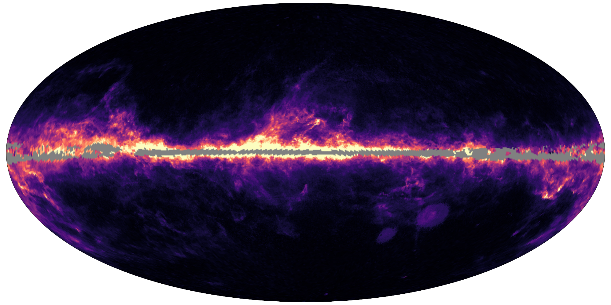
Sky map of total galactic extinction (TGE). Full details in this Gaia DR3 story "what is in between the stars". Credits: ESA/Gaia/DPAC - CC BY-SA 3.0 IGO.
Using a selection of stars from the Gaia DR3 release as extinction tracers, the total Galactic extinction has been calculated across the sky at four different angular resolutions, in the form of HEALPix maps (HEALPix levels 6 through 9).
In addition, for convenience an optimal extinction map is presented with variable resolution, based on the smallest HEALPix with at least 10 extinction tracers. The extinction is provided in units of A0, an extinction parameter which provides the monochromatic extinction at 541.4 nm. As such it provides an estimate of the amount of interstellar matter along the line of sight which is independent of the stellar type of the tracers. More details about this choice can be found in the online documentation, and details about converting A0 to other passbands can be found on the Gaia DR3 extinction coefficients in various passbands page.
The TGE extinction maps are made available on the Gaia Archive in two separate tables, gaiadr3.total_galactic_extinction_map and gaiadr3.total_galactic_extinction_map_opt, which contain for each HEALPix the total line-of-sight extinction from the Galaxy, its uncertainty, along with a number of additional diagnostics, including the number of stars used to calculate the extinction.
Details on the construction of the TGE maps and overall presentation of the results is available in "Gaia Data Release 3: Apsis III - Non-stellar content and source classification" by Delchambre, et al. (2022), with additional details to be found in the online documentation on the Total Galactic Extinction Maps.
The TGE extinction maps at each angular resolution, as well as the optimum map, are also available via the python dustmaps package . Using this tool, it is possible to obtain the line-of-sight extinction at a given sky coordinate, set of coordinates, or sky map of a chosen region in the Galactic or celestial reference frame. One can also obtain the corresponding uncertainty and other selected diagnostics. The dustmaps package already provides access to a number of existing extinction maps, thus facilitating comparison between them.
Download the dustmaps package here
Users of this tool are kindly asked to cite "Gaia Data Release 3: Apsis III - Non-stellar content and source classification" (Delchambre, et al.).
Acknowledgements: ESA/Gaia/DPAC/CU8, with thanks to Greg Green for integrating the TGE map into the dustmaps package.
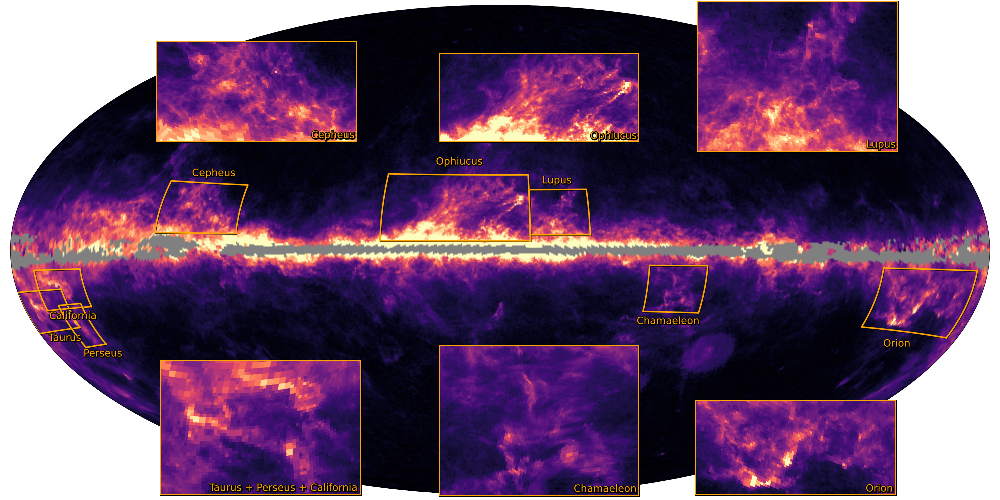
Sky map of total galactic extinction (TGE), with zoom-ins into star formation regions. Full details in this Gaia DR3 story "what is in between the stars". Credits: ESA/Gaia/DPAC - CC BY-SA 3.0 IGO.
Published: 13 June 2022
- Removed a total of (6) style text-align:center;
- Removed a total of (1) style float:right;