Map-based Search - PSA
Map-based Search Interface

The Map-based Search interface is a Java-based application which allows for visual querying of geographically referenced data. It can be used be in combination with the Advanced Search interface to refine your search. Please note that it is currently available only for Mars Express HRSC and OMEGA data of Mars.
Get Started
1. Launch The Interface |
2. Define Your Query |
3. Refine Your Search and Download |
|
Since the Map-based Search Interface is a Java-based application that loads through your web browser, no installation is required. Just click on the green Launch Interface button on this page. However, there are some requirements in order for this interface to run correctly:
|
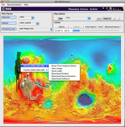
The Map-based Search Interface offers a selection of background maps of Mars on top of which your can draw your Region of Interest. You can then select your Instrument of choice and, if required, an instrument Detector and Processing Level. Excute your query by clicking the Search button, and the Footprints of observations matching your query will be overlayed on the map. |
By clicking on individual footprints, you can:
You can always switch back and forth between the Map-based Search and the Advanced Search Interface to refine your query, or to retrieve the content of your Delivery Basket. |
- Removed a total of (1) align=left.
- Removed a total of (1) border attribute.
- Removed a total of (1) cellpadding attribute.
- Removed a total of (1) cellspacing attribute.

User's Guides
Troubleshooting
For further information on potential problems regarding the Map-based Search interface, take a look at our FAQ page before contacting us.


 Sign in
 Science & Technology
